

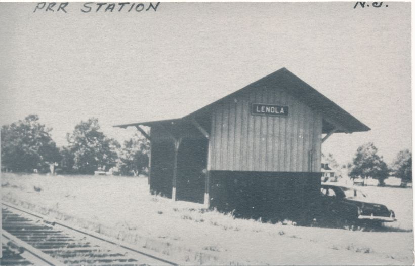
Lenola is now a section of Moorestown Township. Prior to 1922 it was a village in Chester Township as Moorestown was a mile away with farmland in between the two.
Lenola, like Maple Shade, was started by the railroad coming through and placing a station at a road. Lenola station was first called Wilson's station and Maple Shade's Stiles' station.
Lenola had some late 1800s subdivisions, but like Maple Shade it took off with developments for Barlow & Company realtors and developers, the land owned by Horace Roberts. The houses would be predominately bungalows.
Lenola in the mid 20s would get a sizable grade school on New Albany Road. It also had a community center where a 7 Eleven now stands. Perhaps by the increased ownership of automobiles or the growth of Moorestown in general in all directions Lenola stopped thinking of Camden Avenue as its Main Street.
Lenola no longer has a school in its section but does have a fire department. That is actually one thing that keeps the name alive. That and the bungalows as there is no longer a railroad station there called Lenola station.
Lenola has fine parks for sports and is close to many shopping areas. As far as a Main street, community house, library, schools, etc... is, Lenola is in Moorestown and enjoys it as a greater heritage.
-Dennis Weaver
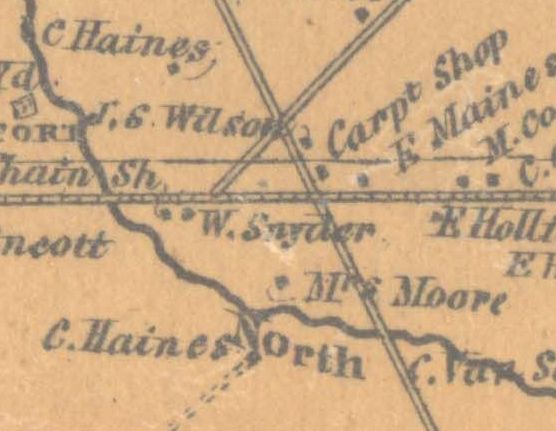
The area that is now Lenola, Moorestown was no more then three roads crossing as they still do today to form a triangle where McDonalds is now located and several family farms.
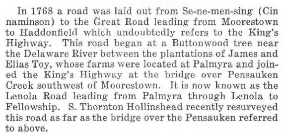
Lenola Road in 1860 was the "Cinnaminson Road to Colestown." It was referred to as the Cinnaminson Road for many years although it predates Cinnaminson by almost a century.
Another road, now New Albany Road, went to a hamlet named "New Albany." On a 1847 map it was called the "Road to Taylor's Fish House" and today you can see how it continues past Rt. 130 as Taylor's Lane.
Camden Avenue is part of the road laid out in 1794 to the Ferry to take farm "truck" etc... to Philadelphia and Camden markets. It started out to take the produce to Cooper's Ferry which crossed the Delaware River to Market Street, Philadelphia and as that place became so traveled through it gave birth to the City of Camden. In 1850 Camden Avenue became the Moorestown and Camden Turnpike. It was purchased by the County in 1907 and the turnpike toll houses discontinued as they interfered with the trolleys. Now it is Camden Avenue, and to Lenola folks Camden Avenue has been referred to as "Main Street."
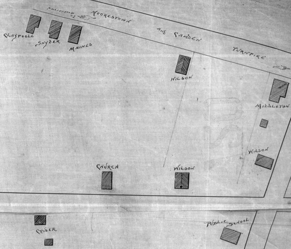
The farms over the years were owned by people such as the Wilson family, the Brown family, the Browning family, the Moore family, the Maines family, the Crider family, the Claypoole family, and the Snyder family.
Today we see the names Wilson, Browning, Moore, Crider, and Claypoole as street names.
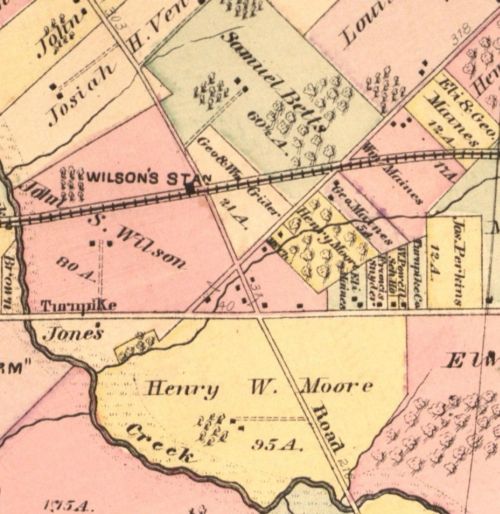
The area became identified with a train station. The area was called Wilson's Station. Later the name was changed by the railroad company to Lenola Station.
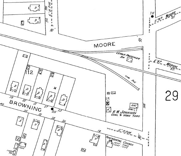

In October of 1867, trains began running on the Camden and Burlington County Railroad, between Mount Holly and Camden, and Moorestown at once became a railroad town connected with Philadelphia and other desirable points. (Loosely quoted from "Moorestown Old and New" by James C. Purdy, Chapter 8, The Coming of the Railroad)
On November 1, 1867, there was a meeting of the Camden and Burlington County R.R. The main discussion was the placement of the Moorestown Station. They wanted to put it at Mill Street. People from the township (or village) had formed two "groups" and made petitions for having it at the eastern and western locations. (Church Street and Chester Avenue.- See also Purdy's book) The R.R. decided that eventually in the long run they would have two stations there so went with putting one at Chester Avenue at this point in time. Then was brought up that there should be two platforms between Moorestown and Merchantville, One at John Wilson's farm (Lenola Road). and one at Thomas Wilson's farm (Forklanding Road). Below is an excerpt from the minutes of that meeting. (State Archives, Trenton, Penn Central Collection)

On motion of M. Markley it was ordered that a platform be erected at Thomas Wilson's and also one at John S. Wilson's between Moorestown and Merchantville, provided the land offered at these points as an inducement shall be conveyed to the company.
(From the New Jersey State Archives, Trenton, NJ, "Penn Central Collection," Box 11, Camden & Burlington County R.R. Board Minutes 2 May 1866- 11 April 1881)
Wilson's Station was put in sometime after January 21, 1870, when the Camden and Burlington County Rail Road Company purchased the land from John S. Wilson. (Deed book D-8, page 99) The Stiles' Station land in Maple Shade was purchased in 1869 so that station would post date that purchase at some point. (BTW- Thomas Wilson was a father-in-law to Benjamin J. Stiles and that area was already called "Stiles Corners." So it wasn't a problem with two Wilson farms for the station locations.)
Deed to R.R. from John S. Wilson, 1870 PDF
The area around Wilson's Station had become known as Wilson's. "Wilson's Station schoolhouse," now a Chistodelphians Church, was later the Lenola School. Sometime around 1891 the railroad station was renamed (by the railroad company) Lenola Station. The exact year still has to be discovered.
My theory is that the R.R. at first named the stations for the farms they purchased land on but later wanted to get away from that as times change and the owners move away or die. This was especially bad in Maple Shade when Benjamin J. Stiles hung himself in his barn and his family and his in-laws were some of the last Stiles families there at "Stiles' Station" and they moved away.
Obituaries from the New Jersey Mirror-
Near Moorestown, May 17th, 1887, John S. Wilson, aged 71 years
At Wilson's Station, August 3, 1887, Mary, widow of the late John S.Wilson, aged 71 years
I really do not know the details of the name change of the station. It sure does seem to be near the time of the first Lenola subdivision. I would think the subdivision followed the name change. William Kingston said a few things about Lenola in his book "Moorestown's Third Century: The Quaker Legacy." I haven't researched them so I don't know if they are true.
In the late 1800s into the early 1900s, despite school districts (could have been used), the archaeological groups saw the brickyards of Maple Shade as land in Lenola. When the brickyards excavated the clay, fossils were found at the sites. The Natural Academy of Sciences in Philadelphia is one group which would go out to the clay pits. If you want to check for fossil finds at the clay pits, try searching under "Google Books"- keywords fossils at Lenola, Graham brickyard, Lenola, or Reeve clay pit, Lenola. Here is one report that does correct the area as Maple Shade- Clay pits with fossils were in Maple Shade.

|

At left is an article from the Mount Holly News, January 31, 1893. |
From the Camden Courier newspaper, Sept. 2, 1925-
|
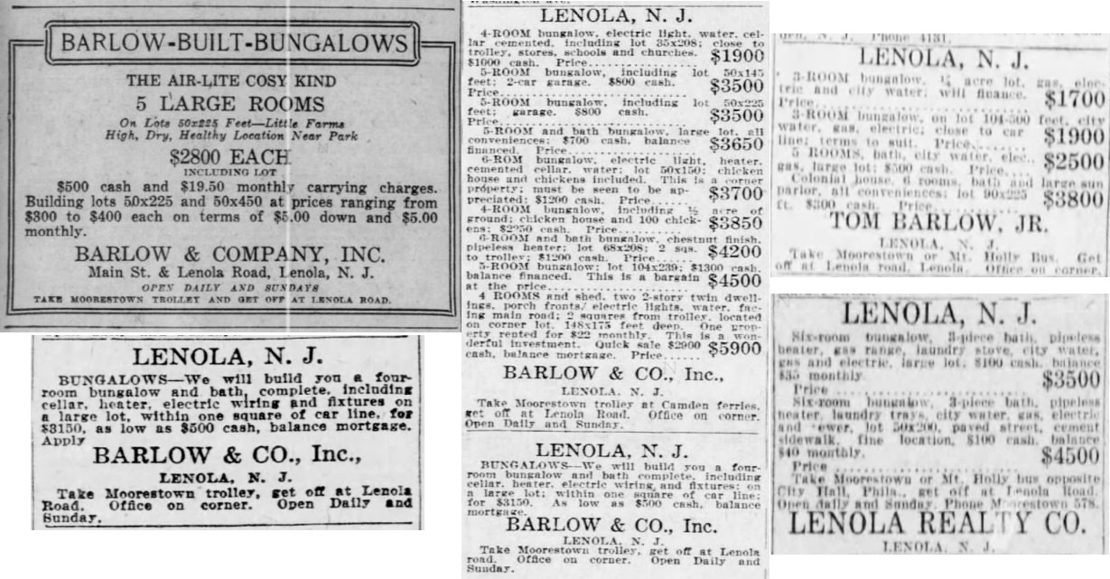
Thomas Barlow of Barlow & Company developers in Maple Shade and Horace Roberts realized the market for affordable blue collar housing and lots. The Horace Roberts bought farms, starting with the Clover Leaf Farm, I believe, brought successful sales where any former brought sparce sales. Bungalows and "One Acre Farms" fullfilled a blue collar city worker's dreams of living in the country!
Thomas Barlow Jr. built a real estate office at the south west corner of Camden Avenue and Lenola Road. (source- Arthur N. Cutler's papers) The office was called "Lenola Realty." This would be the building the "White House" razed for a parking lot, and I believe the building where they are now began as an American Store (Acme).
From the New Jersey Mirror newspaper, April 6, 1921-
Barlow & Company, the real estate operators, are building branch offices at Woodbury Heights and Lenola.

Horace Roberts was a farmer who lived at Hooton Hall, South Church Street. He was a very successful farmer who practiced inter-cropping. That means while you are waiting for the newly planted peach trees to grow, you plant strawberries or tomatoes etc... between them. He would buy run down farms and turned them into productive ones that soon payed for themselves. He at one time had 23 farms which he mostly grew orchards on. He became involved in the real estate business with Barlow & Co. buying up farms mostly in Maple Shade and Lenola for bungalows on regular or "One Acre Farm" lots.

|
Map 720 Filed on May 2, 1891 |
Plan of Lots Lenola, NJ(Map index book says name John S. Collins & SonHis name is not on map though, Moorestown Historical Society has another copy with his name on it.) Surveyed and plotted by E. May Jr, C.E. April 1891 |
Located on the north side of Camden Avenue Streets- Moorestown & Camden Turnpike Cinnaminson Road (Lenola Road) New Albany Road Merion Avenue (along the railroad) Chestnut Main (Errickson Avenue) Moore Street Linden |
|
Map 721 Filed on November 15, 1895 |
Plan of Lots LenolaProperty of William N. TaylorSurvey by E.G. Aitken September 1895 |
Located on the north side of Camden Avenue Streets- Camden & Moorestown Turnpike Cinnaminson Road (now Lenola Road) New Albany Road Moore Street Merion Pariset |
I could not find any evidence that John S. Collins, Irving Collins or William N. Taylor owned the land for the early Lenola subdivision maps listed above. This is probably why Collins name is not on the 1891 Plan Map #720. William N. Taylor might have been a share holder of shares for the Lenola Land and Improvement Company but his name is no where to be found in deeds. Irving Collins does in 1894 buy 30 acres of lots from the Lenola Land and Improvement Company.
I did find a 1923 deed of Irving Collins selling lots to the Edward H. Cutler Company. Actually the first plan map could have started with John S. Collins and Son Irving. Since no name is on the map at the County Clerk's and Moorestown Historical Society has a copy with John S. Collins name, he is involved in the area but didn't seem to buy lots until 1894.


The Lenola Land and Improvement Company bought the first subdivision tract in Lenola (listed above by two others just mentioned) in 1893. The president might have been W.J. Dunn or Frank W. Parvin or William N. Taylor. The vice president was John W. Anderson. The secretary was Fred J. Geiger. One reason we might not see President's names on deeds is people from Philadelphia were involved.
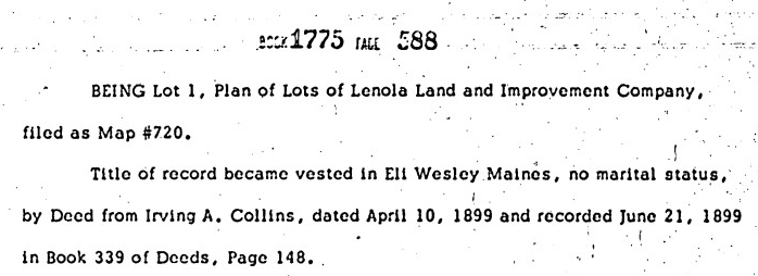
The two subdivisions above are essentially the same and were the plan of the Lenola Land and Improvement Company as well. 401 North Lenola Road, the Eli Wesley Maines house, was Lot #1 in the Plan of Lots Lenola, Map #720. (Reference deed book 309, page 410 Irving Collins buying 30 acres of lots in 1894. Deed book 339, page 148 to Eli Wesley Maines)


|
Map 717 Filed on June 11, 1913 |
Plan of Clover Leaf Farmowned by Horace RobertsBarlow & Co. Developers S.T. Hollinshead Surveyor |
Located on the north side of Camden Avenue Bounded by the railroad and the Pennsauken Creek Streets- Camden Avenue Cottage Avenue Second Street Third Street |
|
Map 719 Filed on May 7, 1918 |
Plan of Lenola Acre Farmowned by Horace RobertsBarlow & Co. Developers S.T. Hollinshead Surveyor April 7, 1918 |
Located on the north side of Camden Avenue Streets- Centre Street Lenola Road Maple Avenue Pine Street |
|
Map 740 Filed on October 2, 1920 |
Plan of Lenola Parkowned by Horace RobertsBarlow & Co. Developers S.T. Hollinshead Surveyor October 1920 |
Located on the south side of Camden Avenue Bounded on the east today by Mount Carmel Cemetery and on the southwest by the Pennsauken Creek Streets- Camden Turnpike or Camden Avenue Revere Avenue Villa Avenue Beacon Street Lenola Road Garfield Avenue Lincoln Avenue Winthrop Avenue |
|
Map 740 1/2 A note on the map- "Not a filed plan, Given to us by Mr. Bowman." |
Plan of Lorraine Farmsowned by Thomas J.S. BarlowBarlow & Co., Inc., Developers Survey by S.T. Hollinshead 1922 |
Located on the east side of North Church Street Streets- North Church Street Perry Stanley Colonial Avenue Walnut Avenue Addison Avenue |
|
Map 743 Filed on October 10, 1922 |
Plan of Lots of
George H. Kraft Surveyor |
Located on the north side of Camden Avenue Streets- Cinnaminson Road (Lenola Road) North Garfield Avenue Maple Avenue Linden Street |
It is the above Theodore Sauselein plan that the article belows states was later "Lenola Gardens." I did not find that Map. I also did not see one for "Lenola Heights," which might be the bungalows near the Cowperthwaite house, Lenola Road and Kings Highway.
 Cowperthwaite house with "Lenola Heights, Barlow & Co. sign" Photo courtesy of the Maple Shade Historical Society |
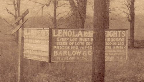 Close up view of the sign |
|
The following article is from the Moorestown Chronicle newspaper, July 27, 1939- Street No Longer Runs Through Living Rooms of Houses in LenolaHow would you like to have a street complete with roadway, sidewalks, water and sewer mains, and gas running right through the living room of your house? It wouldn't be so good, would it? Even if it were only in theory. At any rate that is the situation that has been existing in theory in Lenola for a number of years. In 1895, Theodore Sauselein, of West Main street, Moorestown, who at that time conducted a brick yard in Lenola, owned a tract of land near the Lenola railroad station which he had surveyed by F.C. Aitken, civil engineer. The tract was called "Plan of Land at Lenola Station, Chester Township, Burlington Co., NJ" (The land was then in what at that time was a part of Chester Township- now Moorestown Township.) By 1925 the property had been sold to other interests and the tract was then called "Plan of Lenola Gardens, Lenola, NJ, Moorestown Township, Burlington Co., NJ" This survey was made by S. Thornton Hollinshead, who is now township engineer. The same tracts embraced a section of Lenola bounded by Harding avenue on the north. Moore street on the south, with Garfield avenue to the east and Lincoln avenue to the west. Through this block ran the unamed street from Moore street to Harding avenue, at an angle, and nearer to Lincoln avenue than Garfield avenue. One cannot have clear title to property with a street running through it- even though it has only existed on paper and has no name and has not been accepted by the municipality. So, to clear the matter up, the Moorestown Township Committee made a final passage of an ordinance on Monday evening last "vacating all public right, claim, estate and easement in, to, over, under, and upon such unamed and unaccepted street shown on a certain map of land ____ Lenola, in Moorestown Township." Now everybody is happy and the homeowners no longer have a water main ______ right through the cellar under the living room........ |
It was a section of Chester Township. Moorestown with Lenola separated from Chester Township leaving Maple Shade. This was done in 1922, but was attempted prior in 1917 as them becoming "East Chester" instead of "Moorestown."
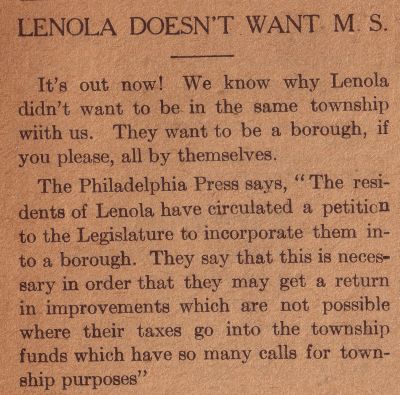
What we are getting at here is the fact that not all the "high and mighty" of Moorestown wanted Lenola either! Before each election took place someone in Moorestown would say somethings bad about Lenola. Below is a clip from the Maple Shade Progress, February 2, 1917-

The result from that above mentioned meeting is that for a brief time there looked like there could have been three townships, Moorestown, Lenola as a borough, and Maple Shade, but soon Lenola was with Moorestown. Each one seemed to think their tax dollars were spent building each other's places. Or so the complaints were.
|

|
In 1921 some of the people in Moorestown were calling the bungalows of Maple Shade and Lenola "cheese boxes."
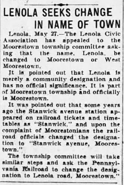
The below article is from the Courier Post newspaper, March 21, 1990
The article is correct except it should say the "southwest corner" for both Barlow offices.-

There is truth though of people "separating people into groups" which wouldn't go over as "politically correct" today.- 1936 Moorestown Recreation talk

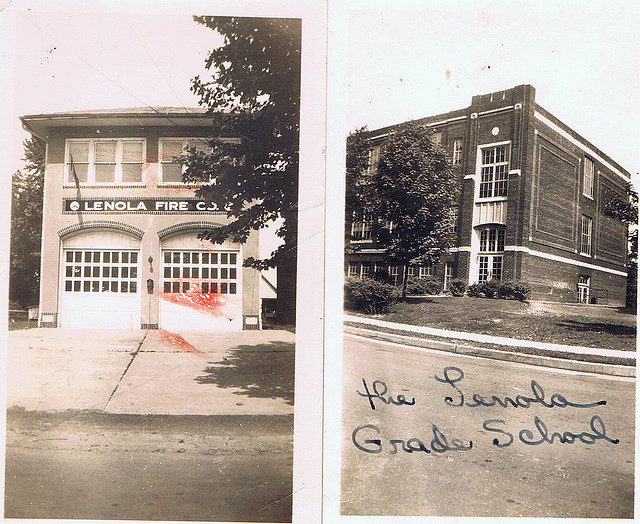
I do not know how I got this photo but I bet I saved it off of Facebook years ago, so if nobody minds I'll put it here. The old firehouse and grade school.
The Lenola School was built in 1924. Mrs. Edith Cutler who was active in the Maple Shade Historical Society was the principal there. Lenola earlier on had a one room schoolhouse and its PTA was started in 1917.

Corporations are listed with the time incorporated and Corporation book and page. Note these books are no longer at the Burlington County Clerk's Office but at Trenton. Even though you find these, at Trenton on their computer they might not. They would do well to find the old record books and put them on the other floor which is the State Archives.
|
Lenola Land & Improvement Co.
Lenola Land & Improvement Co. Lenola Union Church Lenola Civic Club Lenola Fire Company No. 1 Lenola Realty Co. Ladies Auxillary of Lenola Volunteer Fire Co. Lenola Youth Improvement Association Inc. Lenola Hobby Shop Inc. Lenola Fire Co Emergency Unit Inc. Lenola School P.T.A. Lenola Concerned Citizens Inc. Lenola Fire Co. Emergency Unit Inc. (cert. of ammendment) Lenola Emergency Unit Inc. (cert. of ammendment) |
May 13, 1893 Book C, page 282
May 19, 1893 Book C, page 284 March 18, 1902 Book D, page 460 April 26, 1919 Book G, page 495 April 18, 1923 Book I, page 27 May 14, 1930 Book K, page 315 April 5, 1934 Book L, page 299 January 14, 1947 Book O, page 333 May 27, 1954 Book R, page 153 December 30, 1957 Book T, page 454 March 15, 1978 Book 10, page 710 June 12, 1979 Book 11, page 282 July 7, 1981 Book 14, page 38 March 18, 1982 Book 14, page 335 |
Betty's family moved to Lenola in 1936 from Philadelphia. She was six years old at the time. They purchased their bungalow house from Barlow & Company, at their Lenola office on Main Street. (Camden Avenue) The yard was a whole acre and the lots were considered as "One Acre Farms." They payed 1500 dollars for the house. It had an outhouse. When she got married, her father divided his lot and sold her the lot next door.
The nearby farms were the Browning farm back on Lenola Road. Also, Mr. Brown had a farm on the end of Wilson Avenue. The story that she was told and doesn't know if it's true or not, is that Mr. Brown built the little church that is next to the Lenola School. His wife wanted a church is why he built it. Betty went to it for years. It was called the Lenola Union Church.
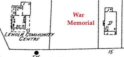
The Lenola community house, officially the "Lenola Community Center" was where the Seven Eleven store now is on Camden Avenue. It had a small library which was an offshoot of the Moorestown Library. The librarian was there a couple days a week. It had a large room with bookcases around the edges. It was used for meetings such as Girl Scout meetings.
Some of the stores in the area were the American Store (now Acme) which was on Main Street. (Camden Avenue) Joe's Sweet Shop was on the corner. Then the American Store, then to the right of the American Store was a little store that had a little Post Office in it at one time which was a branch of the Moorestown Post Office. Then there was a barber shop. It had a t.v. in the window and men would stand out on the sidewalk watching the fights.
On Lenola Road, just across Camden Avenue, on the left side, was a little barber shop added onto a house. That was Mr. Verbaro. Maranatha last used it. They had a youth group meeting there. Now it is torn down. Her nephew, George Brown, was a youth minister at Maranatha and at one time they met in the little church on Browning Avenue. Then they moved to the church building in the parking lot on North Forklanding Road in Maple Shade across from the bank.
At the railroad there was a big house. Mr. Maines had a store there. The kids went there to get penny candy on the way to school. Betty went to the Roxy theatre in Maple Shade and the Criterion in Moorestown to watch movies. The Lenola community house had little dances (record music) on Friday nights for the kids.
There was no big firehouse on Lenola Road then. It was a big field that the kids cut across to get to school on New Albany Road. At the little firehouse (nearer to McDonalds) they had parties upstairs. Maple Shade had dances as well as town meetings above their firehouse. (now Fontanas restaurant)
Betty went to the Lenola School on New Albany Road. The Lenola public school is now apartments. First through sixth grade it was when she went there and she went all through it. In seventh grade she went to the Moorestown Junior/ Senior High School. The bus stop was at the community house, and you had to walk to it to get the bus stop. Her four sons all went through the Lenola School but it ended around fourth grade then.
The Browning's farm had horses and cows and they would bring them the milk (raw milk) by the gallon. One of her first jobs was picking tomatoes on the Browning's farm. On another farm on Lenola Road she picked apples and peaches. Her first job as an adult was in Philadelphia. She would get the train at the Lenola train station to the ferry. She did office work in Philadelphia. She took a business course in school.
Betty was in the Moorestown and Maple Shade Girl Scouts. Mrs. Clark was the leader in Moorestown and Mrs. McGall was the leader in Maple Shade.
There was a lot of people in Lenola that were Italian and came from Philadelphia. One big name was the Perlas. They had the Perla Block Company. (cinder blocks for foundation walls) Betty's husband built their house. He dug out the basement. He would get 25 Perla blocks or whatever they could afford and build as they could get more money. They didn't have a lot of money, but they managed.
Now an industrial park is behind her house, but before it was a big field where corn grew with a woods in the middle of the field. There was a creek that ran through the middle of the field too. They played there. Where Moorestown Mall is was peach or apple orchards.
Where McDonalds is was a large house. That is where her brother-in-law grew up- the Bowen family.
Where Betty grew up they had chickens. Her father and her grandfather had them. Her grandfather lived with them there. At her house nextdoor, after she married, her family also had chickens. She ordered by mail 100 chicks and it turned out to be they were all roosters- so they had no eggs but just ate them. She had horses for her kids. Her son Randy had a horse they bought for 15 dollars (cheap) at an auction. It got sick and died. (lived in the garage) The two boys buried it in the back yard then they had a big rain and it washed up and was floating.
Betty had 2 girlfriends on the other side of Camden Avenue (south side) with ponies. She liked riding and went over after school. I mentioned to Betty the house on Camden Avenue almost to Main Street in Moorestown which had horses into the 1970s. Betty said that close to town they probably weren't allowed but they had them before the law so they could, is what she thinks.
Today, Betty still lives in the house her husband built for them. Her son Tim lives next door where her parent's old bungalow was. He razed it and put a two story house there.

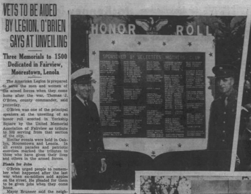

Here is a PDF file of the whole article- Lenola War Memorial.pdf
Here is the area, east of Lenola Road on Camden Avenue, where Betty's photos were taken. The American Store was on the west side of Lenola Road. (BTW- Lenola Road is the point which divides East and West Camden Avenue.)

From the Moorestown News Chronicle, May 5, 1960-Crowds Storm New A&P
|

|
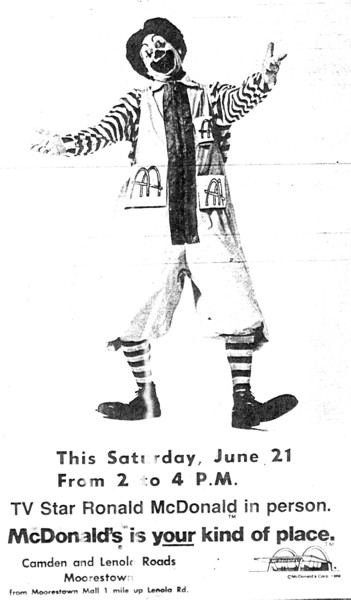
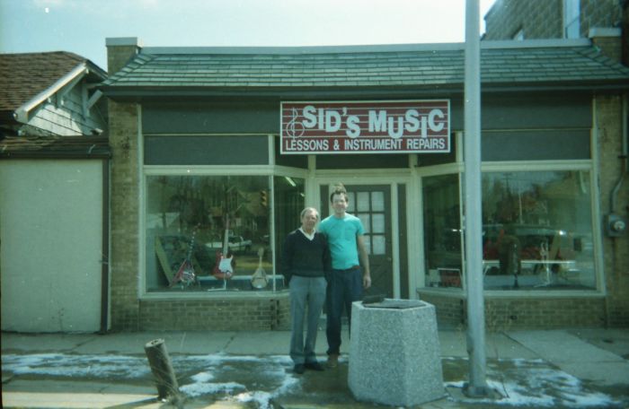
I realize this webpage mostly contains title chains, subdivisions, real estate agents, etc... verses people's stories and lives which really make any place a home. I only know the one lady, interviewed above, as a reference to that. So take what you can from the page's infos and I apologize for not getting into the "lives of the people" in Lenola more over the years of time.
-Dennis Weaver
| Dennis Weaver's Moorestown webpages- | ||||
| Moorestown Our Neighbor | Moorestown Out in the Country books | Lenola | Central Avenue area | Hooton page |